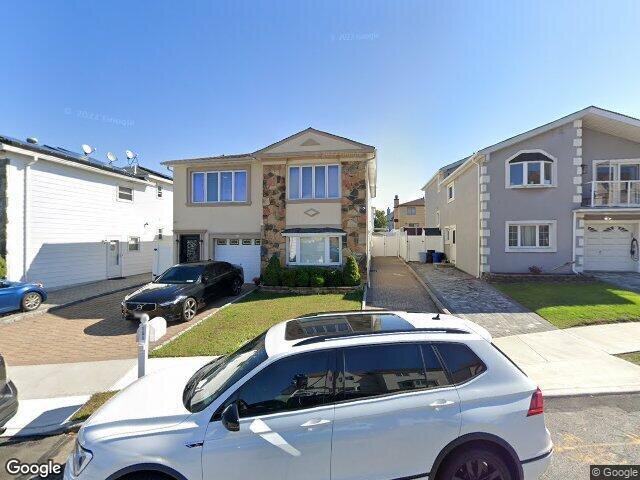
151 Steinway Ave, Staten Island, NY 10314 Richmond County Last Updated: February 28, 2024
Pre-Foreclosure: Lis Pendens, Estimated Market Value $1,017,900
Description: 151 Steinway Ave, Staten Island, NY 10314 is a Multi Family Home built in 1970. This property was last sold for $515,000 in 2004 and currently has an estimated value of $1,017,900. According to the Staten Island public records, the property at 151 Steinway Ave, Staten Island, NY 10314 has approximately 2,106 square feet, with a lot size of 4,528 square feet. Nearby schools include Ps 69 Daniel D Tompkins and Ps 60 Alice Austen.
2,106 sqft
4,528 lot size
Year Built: 1970
Pre-foreclosure
151 Steinway Ave, Staten Island, NY 10314
Last Updated: February 28, 2024
1
Multi Family Home
Estimated Market Value EMV $ 1,017,900
151 Steinway Ave
bool(false)

bool(true)

bool(true)

int(0)
Estimated Market Value EMV $ 1,017,900
Foreclosure History
for 151 Steinway Ave
for 151 Steinway Ave
151 Steinway Ave, Staten Island, NY 10314 is a Multi Family Home built in 1970. This property was last sold for $515,000 in 2004 and currently has an estimated value of $1,017,900. According to the Staten Island public records, the property at 151 Steinway Ave, Staten Island, NY 10314 has approximately 2,106 square feet, with a lot size of 4,528 square feet. Nearby schools include Ps 69 Daniel D Tompkins and Ps 60 Alice Austen.
Property features
Year Built:
Year Built:
1970
1970
Zoning:
Zoning:
R3-1
R3-1
Living Area:
Living Area:
2106
2106
Building Class:
B2
Two Family Dwellings: Frame
Floors on Main Building:
2
Building Dimensions:
29'
Actual Square Footage:
2,106
Calculated Square Footage:
3,132
Residential Floor Area:
2,106
Basement:
Below grade full basement
Address:
151 STEINWAY AVENUE
Borough:
Staten Island (5)
BIN
Name 151 STEINWAY AVENUE
Land Use:
01
One & Two Family Buildings
Calculated Lot Perimeter:
291.70 ft
Irregular Lot:
An irregularly shaped lot
Zoning Districts:
R3-1
Lower-density residence district
Max Residential FAR:
0.50
Max Residential Sqft:
2,264
Buildable Residential Sqft:
158
Residential Area Distribution:
Assessed Land Value:
$12,300
Assessed Total Value:
$54,060
Last Recording Date:
Jan 8, 2024
Property Assessment Data:
Tax Class:
1
One- to three-unit residential properties
Taxable Assessed Value:
$43,992
Estimated Market Value by NYC DOF :
$901,000
Community District (CD):
502
City Council District:
51
Document DateDocument Type Unit Amount
Date
Event
Price
Price/Sqft
Source
Jul 26, 2004
Sold
$515,000
$245
Public Record
Nov 27, 2002
Sold
$435,000
$207
Public Record
Year
Taxes
Land
Additions
Total Assessment
2022
$8,222
$12,300
$36,060
$48,360
2021
$8,177
$12,300
$28,620
$40,920
2020
$7,759
$12,300
$28,560
$40,860
2019
$7,668
$12,300
$30,300
$42,600
2018
$7,610
$11,335
$25,047
$36,382
2017
$6,996
$12,173
$22,150
$34,323
2016
$6,473
$10,089
$22,293
$32,382
2015
$5,973
$8,372
$22,178
$30,550
2014
$5,332
$9,932
$20,387
$30,319
2014
$5,852
$9,133
$21,417
$30,550
2012
$4,914
$16,055
$12,548
$28,603
2010
$4,139
$15,147
$11,838
$26,985
2009
$4,114
$14,208
$11,251
$25,459
2007
$3,479
$3,439
$20,397
$23,836
Address
Price
Built
Beds
Baths
Sqft
Lot Size
Distance
47 Gadsen Pl
Staten Island, NY 10314MF
$803,000
02/20/2024
1985
—
4
2,078
-28difference
3,480
0.05 mi
82 Mulberry Ave
Staten Island, NY 10314MF
$880,000
03/07/2024
1980
3
4
2,155
+49
2,400
0.39 mi
7 Monahan Ave
Staten Island, NY 10314MF
$1,168,000
04/10/2024
2006
5
4
2,168
+62
4,601
0.84 mi
24 Gadsen Pl
Staten Island, NY 10314MF
$945,000
03/21/2024
1970
5
4
2,176
+70
4,760
0.03 mi
221 Braisted Ave
Staten Island, NY 10314MF
$529,875
11/20/2023
1980
4
4
2,032
-74
2,581
0.32 mi
135 Steinway Ave
Staten Island, NY 10314MF
$789,900
12/22/2023
1970
3
2
2,376
+270
4,760
0.03 mi
700 Travis Ave
Staten Island, NY 10314MF
$880,000
11/08/2023
1983
6
4
3,020
+914
4,700
0.06 mi
7 Knapp St
Staten Island, NY 10314MF
$1,020,000
11/10/2023
1970
4
3
2,412
+306
3,807
0.13 mi
206 Freedom Ave
Staten Island, NY 10314MF
$948,000
12/28/2023
1965
3
2
2,556
+450
4,500
0.19 mi
16 Poi Ct
Staten Island, NY 10314MF
$998,000
03/06/2024
1970
5
3
2,516
+410
7,986
0.28 mi
Address
Price
Built
Beds
Baths
Sqft
Lot Size
Distance
101 Gary Ct
Staten Island, NY 10314MF
$950,000
49 days ago
1975
5
3
2,112
+6difference
2,449
1.02 mi
101 Gary Ct
Staten Island, NY 10314MF
$950,000
49 days ago
1975
5
3
2,112
+6
2,449
1.02 mi
428 Bradley Ave
Staten Island, NY 10314MF
$869,999
364 days ago
1960
5
3
2,080
-26
5,700
1.63 mi
67 Lewiston St
Staten Island, NY 10314MF
$950,000
51 days ago
1982
5
3
2,072
-34
3,045
0.82 mi
74 Gary Ct
Staten Island, NY 10314MF
$899,000
94 days ago
1975
6
3
2,068
-38
3,480
1.02 mi
24 Bowling Green Pl
Staten Island, NY 10314MF
$988,000
13 days ago
1975
4
4
2,068
-38
3,690
0.26 mi
143 Kelly Blvd
Staten Island, NY 10314MF
$995,000
128 days ago
1970
4
3
2,038
-68
4,200
0.59 mi
143 Kelly Blvd
Staten Island, NY 10314MF
$995,000
128 days ago
1970
4
3
2,038
-68
4,200
0.59 mi
89 Copley St
Staten Island, NY 10314MF
$1,079,000
48 days ago
1970
3
3
2,188
+82
4,200
0.41 mi
49 Sheraden Ave
Staten Island, NY 10314MF
$899,000
99 days ago
1945
6
3
2,020
-86
12,197
1.71 mi
Estimated values are not a substitute for professional expertise. Contact your RE agent for a market assessment.
School Name
Rating
Grades
Parent Rating
Distance
Ps 69 Daniel D Tompkins
, Staten Island , NY 10314
5 / 10
K−5
0.23 mi
Marsh Avenue School For Expeditionary Learning
, Staten Island , NY 10314
7 / 10
6−8
0.77 mi
Is 72 Rocco Laurie
, Staten Island , NY 10314
7 / 10
6−8
0.14 mi
Bishop Patrick V Ahern High School
, Staten Island , NY 10314
—
—
—
1.18 mi
Ps 60 Alice Austen
, Staten Island , NY 10314
4 / 10
K−5
1.19 mi
Moore Catholic High School
, Staten Island , NY 10314
—
9−12
1.19 mi
Port Richmond High School
, Staten Island , NY 10302
2 / 10
9−12
3.03 mi
Gaynor Mccown Expeditionary Learning School
, Staten Island , NY 10314
6 / 10
9−12
0.80 mi
Csi High School For International Studies
, Staten Island , NY 10314
9 / 10
9−12
0.80 mi
Bishop Patrick V Ahern High School
, Staten Island , NY 10314
—
—
1.20 mi
FEMA Zone (Est.)
X (unshaded)
Flood insurance:
Recommended
Flood risks are increasing as sea levels rise and weather patterns change.
This property has a
Minimal Flood Factor
.
Please Log In
Please wait... If this message is not eventually replaced by the proper contents of the document, your PDF viewer may not be able to display this type of document.
You can upgrade to the latest version of Adobe Reader for Windows®, Mac, or Linux® by visiting
https://get.adobe.com/reader/ this link .
For more assistance with Adobe Reader visit
http://get.adobe.com/reader/ this link .
You can download this PDF-document from
here .