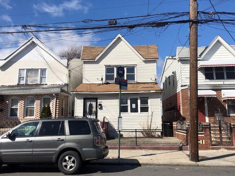
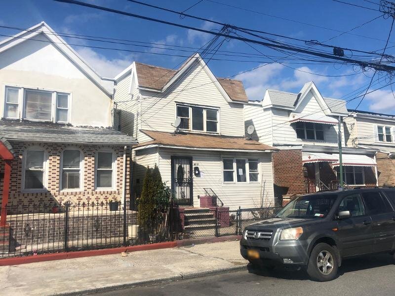
8717 Avenue L, Brooklyn, NY 11236 Kings County Last Updated: June 18, 2023
Pre-Foreclosure: Estimated Market Value $759,800
Description: 8717 Avenue L, Brooklyn, NY 11236 is a Multi Family Home built in 1940. This property was last sold for $460,509 in 2019 and currently has an estimated value of $759,800. According to the Brooklyn public records, the property at 8717 Avenue L, Brooklyn, NY 11236 has approximately 1,760 square feet, with a lot size of 2,583 square feet. Nearby schools include Explore Excel Charter School, Ps 276 Louis Marshall and Ps 115 Daniel Mucatel School.
1,760 sqft
2,583 lot size
Year Built: 1940
Pre-foreclosure
8717 Avenue L, Brooklyn, NY 11236
Last Updated: June 18, 2023
2
Multi Family Home
Estimated Market Value EMV $ 759,800
8717 Avenue L
bool(false)

bool(true)

bool(true)

int(0)
Estimated Market Value EMV $ 759,800
for 8717 Avenue L
for 8717 Avenue L
Last Sold
$460.5K in 2019
8717 Avenue L, Brooklyn, NY 11236 is a Multi Family Home built in 1940. This property was last sold for $460,509 in 2019 and currently has an estimated value of $759,800. According to the Brooklyn public records, the property at 8717 Avenue L, Brooklyn, NY 11236 has approximately 1,760 square feet, with a lot size of 2,583 square feet. Nearby schools include Explore Excel Charter School, Ps 276 Louis Marshall and Ps 115 Daniel Mucatel School.
Property facts
Year Built:
Year Built:
1940
1940
Living Area Size:
Living Area Size:
1,760
1,760
Lot Size:
Lot Size:
0.06 acres
0.06 acres
No. of Stories:
No. of Stories:
2
2
Front Footage:
Front Footage:
25
25
Depth Footage:
Depth Footage:
100
100
Land Area Sqft:
Land Area Sqft:
2,583
2,583
Township:
Township:
CANARSIE
CANARSIE
Property Type:
Property Type:
Duplex, Triplex, Quadplex
Duplex, Triplex, Quadplex
Building Class:
B3
Two Family Dwellings: Converted From One Family
Floors on Main Building:
2
Building Dimensions:
20'
Actual Square Footage:
1,760
Calculated Square Footage:
1,600
Residential Floor Area:
1,760
Basement:
Below grade full basement
Land Use:
01
One & Two Family Buildings
Lot Dimensions:
25.83'
Calculated Lot Perimeter:
266.90 ft
Zoning Districts:
R4A
Lower-density residence district
Max Residential FAR:
0.75
Max Residential Sqft:
1,937
Buildable Residential Sqft:
177
Residential Area Distribution:
Assessed Land Value:
$9,540
Assessed Total Value:
$44,760
Last Recording Date:
Jan 9, 2023
Property Assessment Data:
Tax Class:
1
One- to three-unit residential properties
Taxable Assessed Value:
$30,236
Estimated Market Value by NYC DOF :
$746,000
Community District (CD):
318
City Council District:
46
Document DateDocument Type Unit Amount
Date
Event
Price
Price/Sqft
Source
Nov 29, 2019
Sold
$460,509
$262
Apr 16, 2019
Listed
$300,000
$170
MyStateMLS
Aug 29, 2005
Sold
$559,500
$318
Nov 22, 2004
Sold
$240,000
$136
Year
Taxes
Land
Additions
Total Assessment
2021
$5,669
$9,540
$25,740
$35,280
2020
$5,517
$9,540
$29,760
$39,300
2019
$5,321
$9,540
$33,900
$43,440
2018
$5,270
$6,825
$18,372
$25,197
2017
$4,850
$7,833
$15,963
$23,796
2016
$4,487
$7,300
$15,150
$22,450
2015
$4,247
$9,600
$12,120
$21,720
2014
$4,061
$9,369
$11,829
$21,198
2013
$4,029
$9,281
$11,717
$20,998
2012
$3,610
$13,612
$6,218
$19,830
2010
$3,195
$12,487
$6,222
$18,709
2009
$3,018
$10,295
$8,407
$18,702
2007
$2,550
$2,483
$14,042
$16,525
Address
Price
Built
Beds
Baths
Sqft
Lot Size
Distance
8424 Glenwood Rd
Brooklyn, NY 11236MF
$680,000
03/06/2024
1920
3
3
1,800
+40difference
2,000
0.56 mi
5704 Avenue H
Brooklyn, NY 11234MF
$815,000
03/18/2024
1945
4
3
1,880
+120
1,900
1.00 mi
1139 E 86th St
Brooklyn, NY 11236MF
$875,000
03/11/2024
1950
4
3
1,892
+132
2,150
0.09 mi
1379 E 93rd St
Brooklyn, NY 11236MF
$394,800
02/02/2024
1925
4
4
1,619
-141
3,200
0.29 mi
10216 Avenue K
Brooklyn, NY 11236MF
$770,000
11/21/2023
1955
3
2
1,612
-148
1,927
0.78 mi
1222 E 89th St
Brooklyn, NY 11236MF
$800,000
11/02/2023
—
4
3
1,600
-160
2,000
0.08 mi
1384 Remsen Ave
Brooklyn, NY 11236MF
$925,000
11/16/2023
1960
5
3
2,650
+890
1,900
0.15 mi
1373 E 91st St
Brooklyn, NY 11236MF
$1,200,000
11/15/2023
2023
6
5
2,750
+990
3,310
0.20 mi
1367 E 91st St
Brooklyn, NY 11236MF
$1,275,000
01/05/2024
2023
6
5
2,750
+990
3,249
0.20 mi
1030 E 86th St
Brooklyn, NY 11236MF
$999,999
02/22/2024
2000
6
4
3,160
+1,400
4,833
0.24 mi
Address
Price
Built
Beds
Baths
Sqft
Lot Size
Distance
1054 E 100th St
Brooklyn, NY 11236MF
$749,000
387 days ago
1960
3
3
1,760
2,000
0.66 mi
1154 E 101st St
Brooklyn, NY 11236MF
$699,000
451 days ago
1965
3
2
1,760
2,000
0.68 mi
672 Remsen Ave
Brooklyn, NY 11236MF
$699,000
393 days ago
1935
3
2
1,741
-19difference
2,200
1.37 mi
9125 Kings Hwy
East Flatbush, NY 11203MF
$929,999
347 days ago
1950
6
4
1,800
+40
2,607
1.83 mi
1709 E 51st St
Brooklyn, NY 11234MF
$399,000
1522 days ago
—
5
3
1,814
+54
2,500
1.63 mi
1518 Canarsie Rd
Brooklyn, NY 11236MF
$925,000
479 days ago
1910
6
5
1,816
+56
4,738
0.28 mi
4810 Avenue K
Brooklyn, NY 11234MF
$875,000
394 days ago
1935
5
3
1,696
-64
2,288
1.53 mi
982 E 80th St
Brooklyn, NY 11236MF
$900,000
423 days ago
1960
4
2
1,824
+64
3,300
0.49 mi
1431 Albany Ave
Brooklyn, NY 11203MF
$799,000
538 days ago
1930
5
3
1,838
+78
1,742
1.85 mi
9109 Avenue K
Brooklyn, NY 11236MF
$970,000
353 days ago
1930
7
3
1,872
+112
2,513
0.24 mi
Estimated values are not a substitute for professional expertise. Contact your RE agent for a market assessment.
School Name
Rating
Grades
Parent Rating
Distance
Mesivta Lev Bonim
, Brooklyn , NY 11236
—
9−12
—
0.11 mi
Explore Excel Charter School
, Brooklyn , NY 11236
6 / 10
K−8
—
0.63 mi
Ps 276 Louis Marshall
, Brooklyn , NY 11236
5 / 10
K−5
0.31 mi
Ps 115 Daniel Mucatel School
, Brooklyn , NY 11236
6 / 10
K−5
0.25 mi
Urban Action Academy
, Brooklyn , NY 11236
1 / 10
9−12
—
0.46 mi
Mesivta Lev Bonim
, Brooklyn , NY 11236
—
10−12
0.12 mi
High School For Medical Professions
, Brooklyn , NY 11236
4 / 10
9−12
0.47 mi
Is 68 Isaac Bildersee
, Brooklyn , NY 11236
6 / 10
6−8
0.44 mi
Flood insurance:
Recommended
Flood risks are increasing as sea levels rise and weather patterns change.
This property has a
Minimal Flood Factor
.
Please Log In
Please wait... If this message is not eventually replaced by the proper contents of the document, your PDF viewer may not be able to display this type of document.
You can upgrade to the latest version of Adobe Reader for Windows®, Mac, or Linux® by visiting
https://get.adobe.com/reader/ this link .
For more assistance with Adobe Reader visit
http://get.adobe.com/reader/ this link .
You can download this PDF-document from
here .