1977 Birchall Ave, Bronx, NY 10462 Bronx County Last Updated: July 12, 2023
Pre-Foreclosure: Lis Pendens, Estimated Market Value $918,100
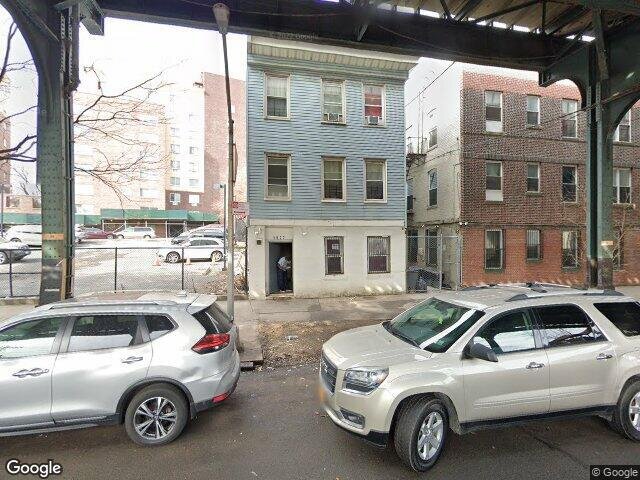
Description: 1977 Birchall Ave, Bronx, NY 10462 is a Multi Family Home built in 1940. This property was last sold for $545,000 in 2005 and currently has an estimated value of $918,100. According to the Bronx public records, the property at 1977 Birchall Ave, Bronx, NY 10462 has approximately 3,402 square feet, with a lot size of 1,925 square feet. Nearby schools include Stem Bridge School (The), Bronx Charter School For Excellence 2, P.S. 83 Donald Hertz and Ps 105 Senator Abraham Bernstein.
3,402 sqft
1,925 lot size
Year Built: 1940
Pre-foreclosure
1977 Birchall Ave, Bronx, NY 10462
Last Updated: July 12, 2023
1
Multi Family Home
Estimated Market Value EMV $ 918,100
1977 Birchall Ave
bool(false)

bool(true)

bool(true)

int(0)
Estimated Market Value EMV $ 918,100
Foreclosure History
for 1977 Birchall Ave
for 1977 Birchall Ave
1977 Birchall Ave, Bronx, NY 10462 is a Multi Family Home built in 1940. This property was last sold for $545,000 in 2005 and currently has an estimated value of $918,100. According to the Bronx public records, the property at 1977 Birchall Ave, Bronx, NY 10462 has approximately 3,402 square feet, with a lot size of 1,925 square feet. Nearby schools include Stem Bridge School (The), Bronx Charter School For Excellence 2, P.S. 83 Donald Hertz and Ps 105 Senator Abraham Bernstein.
Property features
School District:
School District:
Addison
Addison
Bathroom 2 Description:
Bathroom 2 Description:
0
0
Total Bathrooms:
Total Bathrooms:
0 / 0
0 / 0
Lot Size Acres:
Lot Size Acres:
0.0459137
0.0459137
Lot Size Square Feet:
Lot Size Square Feet:
2000
2000
Sewer:
Sewer:
Municipal
Municipal
Water Source:
Water Source:
Municipal
Municipal
Below Grade Unfinished Area:
Below Grade Unfinished Area:
1
1
Elevator:
Elevator:
No
No
House Style:
House Style:
Townhouse
Townhouse
Dishwasher:
Dishwasher:
N
N
Garbage Disposal:
Garbage Disposal:
N
N
Kitchen Description:
Kitchen Description:
100
100
Kitchen Type:
Kitchen Type:
100
100
Microwave:
Microwave:
N
N
Refrigerator:
Refrigerator:
N
N
County:
County:
36005
36005
Property Subtype:
Property Subtype:
townhouse
townhouse
Source Listing Status:
Source Listing Status:
Expired
Expired
Source Neighborhood:
Source Neighborhood:
BRONX
BRONX
Source Property Type:
Source Property Type:
Single Family Detached
Single Family Detached
Source System Name:
Source System Name:
C2C
C2C
Building Class:
C0
Walk Up Apartments: Three Families
Floors on Main Building:
3
Building Dimensions:
21'
Actual Square Footage:
3,402
Calculated Square Footage:
3,150
Basement:
Below grade full basement
Address:
1977 BIRCHALL AVENUE
BIN
Name 1977 BIRCHALL AVENUE
Land Use:
02
Multi-Family Walk-Up Buildings
Calculated Lot Perimeter:
211.45 ft
Zoning Districts:
R7-1
Moderate-density residence district
Max Residential FAR:
3.44
Max Residential Sqft:
6,622
Buildable Residential Sqft:
3,220
Residential Area Distribution:
Assessed Land Value:
$10,560
Assessed Total Value:
$51,300
Last Recording Date:
Jan 8, 2024
Property Assessment Data:
Tax Class:
1
One- to three-unit residential properties
Taxable Assessed Value:
$32,893
Estimated Market Value by NYC DOF :
$855,000
Community District (CD):
211
City Council District:
13
Document DateDocument Type Unit Amount
Date
Event
Price
Price/Sqft
Source
Dec 22, 2018
Listing removed
$349,000
—
MyStateMLS
Apr 21, 2018
Listing removed
$349,000
—
MyStateMLS
Apr 20, 2017
Listed
$349,000
—
MyStateMLS
Oct 14, 2005
Sold
$545,000
$160
Public Record
Jan 5, 2005
Sold
$238,500
$70
Public Record
Year
Taxes
Land
Additions
Total Assessment
2022
$6,194
$10,560
$33,120
$43,680
2021
$6,481
$10,560
$29,640
$40,200
2020
$6,150
$10,560
$28,680
$39,240
2019
$5,734
$10,560
$25,260
$35,820
2018
$5,410
$10,560
$15,300
$25,860
2017
$5,740
$9,834
$18,327
$28,161
2016
$5,311
$9,886
$16,682
$26,568
2015
$5,195
$8,614
$17,954
$26,568
2015
$5,051
$8,442
$17,926
$26,368
2014
$4,773
$15,351
$9,525
$24,876
2011
$4,030
$16,440
$5,700
$22,140
2010
$4,744
$16,440
$5,700
$22,140
2009
$4,405
$16,241
$11,085
$27,326
2007
$3,644
$6,022
$17,594
$23,616
Address
Price
Built
Beds
Baths
Sqft
Lot Size
Distance
1705 Hone Ave
Bronx, NY 10461MF
$912,000
04/08/2024
1925
4
—
2,340
-1,062difference
3,742
0.78 mi
1735 Hone Ave
Bronx, NY 10461MF
$942,000
11/09/2023
1925
3
3
2,183
-1,219
5,000
0.74 mi
1735 Hone Ave Unit Townhouse
Bronx, NY 10461MF
$942,000
11/09/2023
1925
3
3
2,183
-1,219
5,000
0.75 mi
1818 Haight Ave
Bronx, NY 10461MF
$690,000
03/21/2024
1940
3
3
1,782
-1,620
1,800
0.82 mi
Address
Price
Built
Beds
Baths
Sqft
Lot Size
Distance
1122 Elder Ave
Bronx, NY 10472MF
$1,285,000
43 days ago
1928
10
4
3,362
-40difference
2,500
1.61 mi
705 E 183rd St
Bronx, NY 10458MF
$885,000
199 days ago
2000
6
3
3,450
+48
1,725
0.89 mi
1612 Haight Ave
Bronx, NY 10461MF
$1,200,000
255 days ago
1899
8
5
3,339
-63
2,500
0.96 mi
2531 Woodhull Ave
Bronx, NY 10469MF
$1,800,000
81 days ago
1945
—
—
3,472
+70
8,002
1.74 mi
1634 Hering Ave
Bronx, NY 10461MF
$1,350,000
3 days ago
1928
—
—
3,328
-74
4,927
1.10 mi
1814 Mayflower Ave
Bronx, NY 10461MF
$1,250,000
30 days ago
2000
5
3
3,327
-75
—
1.82 mi
1039 Lowell St
Bronx, NY 10459MF
$900,000
64 days ago
1930
8
5
3,320
-82
2,500
1.84 mi
2358 Lorillard Pl
Bronx, NY 10458MF
$999,000
8 days ago
1901
6
2
3,500
+98
2,500
1.19 mi
992 Jennings St
Bronx, NY 10460MF
$1,150,000
121 days ago
2003
7
5
3,300
-102
1,498
1.57 mi
1103 Fteley Ave
Bronx, NY 10472MF
$1,350,000
25 days ago
1928
—
—
3,280
-122
2,526
1.50 mi
Estimated values are not a substitute for professional expertise. Contact your RE agent for a market assessment.
School Name
Rating
Grades
Parent Rating
Distance
St Anthony School
, Bronx , NY 10460
—
K−8
0.76 mi
Stem Bridge School (The)
, The Bronx , NY 10462
10 / 10
K−5
0.40 mi
Bronx Charter School For Excellence 2
, The Bronx , NY 10462
10 / 10
K−5
0.31 mi
P.S. 83 Donald Hertz
, The Bronx , NY 10462
7 / 10
K−8
0.52 mi
St. Clare School
, Bronx , NY 10461
—
PK−8
0.65 mi
Bronx High School For The Visual Arts
, The Bronx , NY 10462
4 / 10
9−12
0.29 mi
Ps 105 Senator Abraham Bernstein
, The Bronx , NY 10462
3 / 10
K−5
0.30 mi
Astor Collegiate Academy
, The Bronx , NY 10469
3 / 10
9−12
0.92 mi
High School For Language And Innovation
, The Bronx , NY 10469
4 / 10
9−12
—
0.92 mi
Iahd-St. Mary & St. Jude
, Bronx , NY 10462
—
—
0.80 mi
FEMA Zone (Est.)
X (unshaded)
Flood insurance:
Recommended
Flood risks are increasing as sea levels rise and weather patterns change.
This property has a
Major Flood Factor
.
Please Log In
Please wait... If this message is not eventually replaced by the proper contents of the document, your PDF viewer may not be able to display this type of document.
You can upgrade to the latest version of Adobe Reader for Windows®, Mac, or Linux® by visiting
https://get.adobe.com/reader/ this link .
For more assistance with Adobe Reader visit
http://get.adobe.com/reader/ this link .
You can download this PDF-document from
here .